Science for Everyone

Forest Health Assessment Results

Post by Chloe Tremper, Science and Education Intern 2014

Throughout this past summer, I have gotten to know the forests of Hurricane very well, particularly the spruce-fir stand on the northern half of the island along Slocum’s Trail.  Red spruce (Picea rubens) is by far the most dominant species on the island but is generally only found in the interior the spruce-fir stand on the island.  White spruce (Picea glauca) lines the edges of the stand along trails and the coast but is completely absent from the interior of the stand.  This reflects the white spruces near inability to survive in suppressed conditions and reproduce in closed canopy conditions.  Balsam fir (Abies balsamea) is the last species of tree I found within my study area and the least abundant.  However, when it was found it was generally in plots near the coast and it was always found in concentrated groups.

0
0
1
8
50
Hurricane Island Foundation
1
1
57
14.0


Normal
0


false
false
false

EN-US
JA
X-NONE


 <w:LatentStyles DefLockedState="false" DefUnhideWhenUsed="true"
DefSemiHidden="true" DefQ…

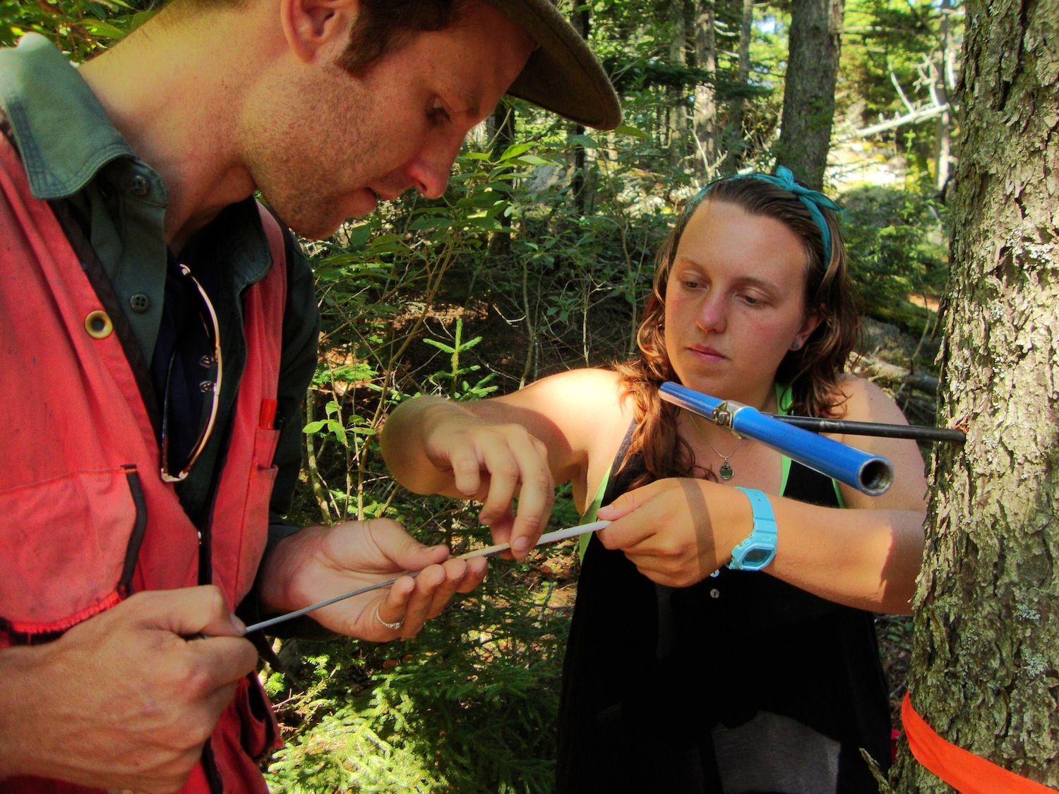
Coring a red spruce to count growth rings to estimate age

Very few of the trees within my sampling area had reached their full growth potential, despite some of them being well over one hundred years old.  This can mostly be attributed to having grown in a less than favorable environment with high competition for very limited resources among individual trees.  Hurricane’s climate (particularly its regular inundation of ocean fog) and shallow, acidic soils are two factors making the island a harsh environment for the trees to survive in. 

Overall, Hurricane’s spruce-fir stand is doing pretty well.  Fire is the biggest risk currently facing Hurricane’s forest due to the massive amount of dead woody debris on the forest floor and the fact that spruce needles are extremely flammable.  The possibility of windthrow (when trees are uprooted by wind) is also fairly high due to the shallow soils and the naturally shallow rooting systems of spruce and fir trees. There is also the potential for an infestation of witches’ broom (a dense mass of shoots growing from a single point off a tree caused by variety of things – generally fungi or a virus) as it is already present on some of the spruce trees along the eastern coast of the island. 

Subscribe in a reader

Visit to Great Duck

View of the keeper's house from the lighthouse.

View of the keeper's house from the lighthouse.

We are in the formative stages of building a field research station on Hurricane Island – an exciting, but also challenging time in figuring out the right scale for a station on an island in Penobscot Bay. During this process, I have found discussions with scientists who run field stations invaluable in guiding my thinking on the development of our station. On July 12, 2014, I had the opportunity to visit College of the Atlantic’s (COA) Alice Eno Field Research Station on Great Duck Island. COA, the State of Maine, the Nature Conservancy, and a private residence share the 220-acre island. We took COA’s research vessel, a 46’ West Mac, from COA’s campus in Bar Harbor out to the island. The facilities are modest and completely off the grid which is similar to Hurricane. I gained important insight into the appropriate scale of necessary infrastructure to support researchers for a period of time on an island.

Each summer, Dr. John Anderson, a COA faculty member, oversees a team of six to seven students that conducts research on Great Duck, often focusing on the breeding populations of Leach’s Storm Petrels and resident Herring and Black-backed Gulls that nest on the island each year. Through cooperative agreements, COA students can access the majority of the island to conduct research projects.

Great Duck and Hurricane have some interesting similarities and differences. Both were inhabited and used by humans in the nineteenth and early twentieth centuries; Hurricane supported a thriving quarry town while Great Duck had a lighthouse keeper’s family and a flock of sheep (for more on Great Duck's history, click here). Hurricane was subjected to a second period of human pressure from the 1960s to the mid-2000s. Once these inhabitants left their respective islands, vegetation was released from human pressures and regenerated. Spruce-fir forests now dominate both islands; however, Great Duck has a stand of similarly aged trees as saplings rarely survive due to grazing of introduced hare while on Hurricane, we have a number of young spruce trees and will potentially experience overcrowding issues. We do have a number of deer on Hurricane, but have not yet quantified their grazing effect on our vegetation. 

Subscribe in a reader

Intertidal Surveys of Hurricane Island

Post by Collin Li, Research and Education Intern, University of Miami

Over the course of my studies I have found that scientists are obsessed with recording change over time. With the world constantly changing around us, it only makes sense to document changes, ask questions to help identify the cause behind our observations, and provide explanations for what we see. Here at Hurricane Island, we are no exception, although we are just beginning to establish our monitoring sites in order to observe change. It is my goal this summer to create a protocol so that the intertidal systems along the shores of Hurricane Island can be sampled and observed over time. I have selected two sites: one at Valley Cove and one at Two Bush Island (which connects to Hurricane Island at low tide). Each site was selected for its gentle slope and distance of the barnacle line to the water line. What makes these two locations differ is that Two Bush is an exposed coastal line whereas Valley Cove is protected. The differences between the zonation structure and organisms found at these two sites will be interesting to quantify. Another main difference between these sites is that Two Bush Island is often used for hands-on intertidal work with students whereas Valley Cove is relatively untouched. We are curious to see if there is a noticeable difference or impact on the intertidal organisms that see higher human traffic. I have established three permanent transects at each site, so that the project can be revisited each year. The high point of each transect was determined by finding the point on the intertidal 13.5 feet above Mean Low Water. Afterwards, each foot decrement was marked off dividing the transect into 13 levels. At each level, a 20cm x 20cm quadrat is sampled at a point most representative of the level.  We plan to monitor these sites over the years, and think about the changes we observe within the context of global sea level rise, ocean warming, and ocean acidification. Best of all, students in our Marine Ecology ISLE programs will help us monitor these sites and contribute to the research that happens on Hurricane Island. 

Subscribe in a reader

Forest Health Assessment of Hurricane Island

Post by Chloe Tremper, Science and Research Intern, Project Update 

For my summer research project, I am completing a forest health assessment of the spruce-fir stand on the northern half of Hurricane Island.  Forest health and how to assess it is hugely subjective depending on the forest type you’re working with and what your definition of “healthy” is.  For this particular assessment I decided to focus on damage and disease within the forest, regeneration, blow down risk, and fire risk.  Since little is known about Hurricane’s forests, my project aims to determine any major risks currently facing the spruce-fir stand on the island as well as recommend any needed management and improved methods of monitoring the overall forest health into the future.

In order to complete this assessment in a few short weeks by myself, I decided to collect data at 12 plots within the spruce-fir stand.  Using Slocum’s Trail as the base of my 600m transect, I used a random number generator to determine 12 random distances between 0 and 600m.  After each of these distances were measured out and flagged, the real fun began! At each distance in from the start of the transect, I start by flipping a coin to determine if the plot will be on the left or right side of the trail: heads means right and tails means left.  After that, I roll a di to determine the distance into the stand I go from Slocum’s (1=5m, 2=25m, 3=50m, 4=75m, 5=100m, 6=150m).

Chloe enters data with ISLE botany students recording DBH for white and red spruce trees in a plot

Chloe enters data with ISLE botany students recording DBH for white and red spruce trees in a plot

Once at each plot center, I set up a 5x5m square plot.  Within that plot I record the species, DBH (diameter at breast height), and signs of damage/disease for each tree.  I am also recording the number of 1-hour, 10-hour, 100-hour, and 1000-hour fuels. 1-hr fuels are debris less than 1/4in diameter (twigs, needles, dead grass), 10-hr are woody debris 1/4 – 1in in diameter, 100-hr are woody debris 1 - 3in in diameter, and 1,000-hr are woody debris greater than 3in in diameter. These numbers are important for estimating the risk of a fire within the stand as well as how much potential damage a fire would cause.  I also tally the number of spruce saplings, fir saplings, Vaccinium spp., and other woody saplings or shrubs in order to get an idea of what would likely take over a plot if the large trees were to die back.  Once all these data are recorded, I measure the soil depth in the northwest corner of each plot.  Knowing the soil depth is helpful in considering the risk of blow-downs. 

I am taking notes about each plot including information about the openness of the canopy, exposed bedrock, fallen trees, herbaceous cover, etc.  So far, I have 8 of the 12 plots completed.  I finished 3 of these plots with help from our SLE Botany students! Of the plots I have completed, I’ve noticed a lot of diversity among them, however the one thing I have seen throughout is a lot of dead woody debris which puts the island at a huge risk if there were to ever be a fire on the island.  Remember, only you can prevent forest fires! 


Subscribe in a reader

The Ferns of Hurricane Island

Post by Chloe Tremper, Science and Education Intern

If you find yourself hiking around Hurricane Island's trail system and come across a fern, take a closer look! Can you identify it? Here are different types of ferns we have found this summer. It may help to check out this helpful diagram showing fern anatomy before reading below.

Mountain Wood Fern Dryopteris campyloptera (Kunze) Clarkson.

Sori of the Mountain Wood Fern

Sori of the Mountain Wood Fern

Mountain Wood Fern

Mountain Wood Fern

Mountain wood fern is one of, if not the most abundant fern species on Hurricane Island as it can be seen on nearly every part of the island. These ferns inhabit cool forests throughout New England, though typically are only found on higher elevations in more southern states, hence the name “mountain” wood fern.  Its thrice-pinnate leaf blade, pale green kidney-shaped sori (the little dots on the underside of the main fern blade), brown scales on the leaf stalk, and the veins, which do not reach the edge of the leaf blade, help easily identify this species. Fun Fern Fact: Native Americans used a tea of the leaves to treat stomachaches and used the rhizomes for food.

Rock Polypody Polypodium virginianum L.

Rock Polypody

Rock Polypody

Rock polypody is another common fern on Hurricane, however you have to know where to look.  Rock polypody often grows directly on rock or on thin soil over rocky cliffs and boulders. We’ve found it growing all over many of the granite rock outcrops within the shade of the spruces and firs here on the island. The blade of rock polypody is once-pinnate and lobed with large, circular sori that tend to be brown in color.  If you look closely at the blade of rock polypody, it almost looks like the pinna are all connected and smoothly zig-zagging back and forth. Fun Fern Fact: It was widely used by Native Americans as a medicinal herb to treat stomachaches, colds, coughs, and other ailments.  


Cinnamon Fern Osmundastrum cinnamomeum (L.) C. Presl

Cinnamon Fern

Cinnamon Fern

Cinnamon fern is abundant along trails mostly on the northern half of Hurricane Island, and these ferns are typically found along water edges and within forests.  Cinnamon fern is a large fern that grows in rounded clumps with fertile fronds emerging from the center.  Unlike mountain wood fern and rock polypody, which have spores on the undersides of their pinna, the spores of cinnamon fern are all found within modified leaflets on individual fertile fronds which look very different from the sterile fronds.  The sterile fronds of cinnamon fern are twice-pinnate and can grow to be over three feet in length and the fertile fronds are erect with cinnamon colored sporangia covering the top of the stalk. Fern Fun Fact: Cinnamon fern fiddleheads are mildly toxic and are often mistaken for ostrich fern fiddleheads, which are commonly collected for food in the spring. Careful what you harvest!


Sensitive Fern Onoclea sensibilis L.

Sensitive Fern

Sensitive Fern

Sensitive fern is fairly abundant on Hurricane Island, especially in poorly drained areas open areas as sensitive ferns are indicators of wet sites and are one of a few ferns that are sun-tolerant.  The blade is once-pinnate with slightly lobed margins on the pinna and a light yellow-green color.  Like cinnamon fern, sensitive ferns have fertile fronds that look like rows of black capsules along the top of an erect stalk growing along with the sterile fronds. Fern Fun Fact:  Sensitive fern received its name because the sterile fronds are very susceptible, or sensitive, to frost damage.


Interrupted Fern Osmunda claytoniana L.

Interrupted Fern

Interrupted Fern

Interrupted fern is a very common fern found throughout New England, however we have only found it one location on Hurricane Island so it’s a rare one for us.  They are generally found in forests and along water edges.  The leaf blade is twice-pinnate and many fronds have distinct interruptions at the center of the frond caused by fertile pinnae. The fertile pinnae are generally chestnut-brown to black in color and close to the stalk.  Fern Fun Fact: Interrupted fern has the oldest known fossil record of any living fern in the world, it's been around for 200 million years!


Royal Fern Osmunda regalis L.

Royal Fern

Royal Fern

Royal fern is a species found commonly around the world, however we’ve only found it in one location on Hurricane so it gets treated like royalty here! Royal ferns are often found by water and within forests.  The leaf blades of the sterile fronds are twice pinnate with a gap between each pinna.  The fertile fronds rise above the sterile fronds and are somewhat crown shaped, thus the name royal fern. Fern Fun Fact: Royal fern is the largest fern found in North America and the young fiddleheads are edible.

Whew! That's all the ferns we've found for now, but stay tuned, and see if you can find any of these ferns growing around your own home or neighborhood! I recommend A Field Guide to Ferns and Their Related Families: Northeastern and Central North America (A Peterson field guide) if you are looking to become a fern expert :) Happy fern finding!

Subscribe in a reader