Island Updates

intertidal

Ashwood Waldorf School

Looking at lichens in the lab with Alice before the lichen hike

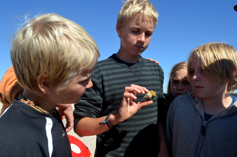
Enjoying the intertidal on Two-Bush Island

The Ashwood Waldorf School from Rockport, Maine joined us on Hurricane for two days of island exploration. For the Botany focus of this program Alice took them on a walk around the island to find and identify the three main categories lichens: crustose, foliose, and fruticose. Another hike focused on the wild edible plants on the island, as well as what plants are flowering out during this stage of spring. Students also got a chance to explore the intertidal area between Hurricane and Two Bush Island. They found lots of fun and interesting intertidal creatures, and learned how kelp survives as a marine plant.

The last day was spent rock climbing. Students learned about different types of climbing gear, how to boulder on granite blocks that were cut from the main face over a century ago, and how to belay and support one another while climbing. Everyone completed their own successful climbs and enjoyed being able to reach the top and enjoy the view out over the open ocean.

One of the best parts of this program was having Ashwood’s program overlap with Nobleboro Middle School. While it can be a dance for us instructors of who is teaching what to who, when and where, it’s great to see us all gathered together at meal times, sharing our island stories from the day!

Subscribe in a reader

Cambridge School of Weston 2015

After towing around a fine-mesh net to collect plankton, students spent time looking into their microscopes trying to identify the critters wiggling around in their petri dishes. 

Learning about what it takes to be a lobsterman from Jason Day

Marilyn works with students in the intertidal between Hurricane and Two Bush Island to make sure their methods are supporting their driving question

For the second year in a row (read about last year's program here), the Cambridge School of Weston came out to Hurricane Island during the lowest tide cycle of May. Seven students and two staff joined the Hurricane community, conducting independent intertidal projects as well as two group projects focused on the quarry and on identifying marine zooplankton.

Students arrived on the island with lots of ideas for their independent projects, and after the first few days exploring Hurricane's rocky intertidal environment, they worked to modify their ideas into testable questions. 

Their projects ranged from observing parental care of dog whelks over their egg patches, to determining whether different species of hermit crabs preferred to be more or less roomy in their shell, to quantifying the range of shell colors in smooth periwinkles and whether that impacted the type of brown algae they were most often associated with. 

Low tide doesn't always wait for breakfast, so students had a few early days, heading out to their study sites by 6:30am! Doing field work in the intertidal can also be challenging because there is just about an hour-long window of time to gain access to your study site before the next low-tide cycle. This meant students had to have all of their scientific gear organized, and a clear plan for their sampling strategy in order to collect the data they needed each day.

Another goal of this program was for students to learn about some of the fisheries that are core to Maine's identity. We travelled out on Vinalhaven fisherman Jason Day's lobster boat to see him haul his traps, learn about the regulations in the industry, and get a sense of the ratio of lobsters that are thrown back to 'keepers.' We also spent time talking about Maine's scallop fishery with Cait Cleaver, our director of science and research. Cait shared about the research she is coordinating to look at the effectiveness of small-scale closures in managing the scallop fishery. After learning about her project, we all helped her build spat bags, which she will deploy in the fall to collect larval scallops. If larval scallops are found in or around the closed area, these data can help Cait get a sense of whether new scallops are settling in the area.

It was a pleasuring hosting this group and I am always impressed by the observations and creative questions that students generate when they have a chance to be immersed in field work! We look forward to seeing the finished reports of the projects, and for next year's group to build on the great ideas and questions from this program!

Be sure to check out the CSW blog about their experience for more photos!

Students enjoy a great view of the sun setting across the bay

Subscribe in a reader

Bowdoin Coastal Studies Center courses

Guest post by Bowdoin instructor Sarah Kingston

Bowdoin College is running two new field-based courses this fall out of their Coastal Studies Center on Orr’s Island: Dimensions of Marine Biodiversity (David Carlon, Director of the Coastal Studies Center) and Marine Molecular Ecology and Evolution (Sarah Kingston, Doherty Marine Biology Postdoctoral Scholar).  Students and Instructors from both courses spent a weekend on Hurricane Island in October, 2014 as a portion of their field seasons.

The Dimensions of Biodiversity class is starting the collection and curation of a long-term dataset to assess changes in the intertidal community as climate changes in the Gulf of Maine.  The Marine Molecular Ecology and Evolution course is executing a population level study of Littorine snails (periwinkle snails) in the Gulf of Maine (utilizing next generation sequencing technology).

Intertidal Monitoring work

Intertidal Monitoring work

The Bowdoin group arrived on a bit of a grey Friday afternoon.  Despite the cloudy skies, the ride over from Rockland was a beautiful panorama of rocky shores and pine-crested islands.  Hurricane was welcoming with warm food and drink as well as cozy cabins.  The students were embarking on quite the field adventure, given the rain in the forecast for the next day.

The Bowdoin visitors targeted two sites: a sheltered section at Gibbon Point, and an exposed, wave-impacted, portion across from Two Bush Island.  The Dimensions of Biodiversity class installed permanent markers (bolts drilled into the rock) for three different tidal level transects: low, medium, and high.  They dutifully collected the first year’s worth of data using quadrats and microquadrats to subsample the area along the transects.  Students noted presence and abundance of organisms in the community like algae, snails, crabs, and barnacles.  The Marine Molecular Ecology and Evolution students collected Littorina saxatilis from rocky crevices in the upper intertidal as well as Littorina obtusata hiding amongst the rockweed in the mid- and lower intertidal before helping their classmates on the transect surveys.

Rain, from mist to a steady fall, persisted throughout Saturday’s work.  The chilly water did not dampen spirits, however, as students and instructors alike explored tide pools, even happening upon a resident starfish.

Nightfall brought about another warm meal gathering.  Students shook off the cold, damp day, and embarked on course discussions and mid-term studying.  Hurricane Island turned out to be the perfect place to focus on scholarship after a long day in the field.

Sunday’s weather evolved from an eerie morning fog into a bright, sunny afternoon.  The Two-Bush Island site was a little trickier to execute, as the wave action added another unpredictable component.  Quadrats on transects were counted on the falling tide; a permanent data logger was installed on the lowest transect to record temperatures throughout the year.

The warmth of the afternoon sun provided a perfect environment in which to reflect on the weekend’s experiences. ​ 

Subscribe in a reader

Northeast High School

For our final program of the season, we were lucky to be joined by 32 enthusiastic students and staff who made a seven-hour trek up from Philadelphia to experience Hurricane Island from October 5-9, 2014! Students spent the first part of the program learning about the botany, geology, history, intertidal zone, birds, sustainable infrastructure, and lobster industry that are all unique to Hurricane's island ecology.

The main focus of this program was for students to fulfill one of their IB Diploma requirements by completing a group project to "find a question to answer utilizing scientific reasoning and investigation." Students split into five groups, and based on the subject that peaked their interest over the first few days of exploration on Hurricane, these groups generated potential questions they wanted to pursue. From those questions, we spent time discussing how questions drive our experimental design, and worked to help students come up with an appropriate sampling approach to address their question. After everyone was clear on the data they needed to collect, the protocol to follow in order to collect data consistently, and the field equipment they needed, groups set out for a day of field work.

Group 1 with their presentation visuals: students showed their results clearly in a bar graph, and also generated a great visual of their sampling site.

The first group focused on the intertidal zone, and was interested to see if the invasive green crabs we find on Hurricane prefer to live in a specific area of the intertidal. These students learned how to use a leveling rod and a sighting compass to make sure that they were collecting comparable tide heights regardless of the slope and terrain in the intertidal. They chose the intertidal zone between Hurricane and Two-Bush Island as their site for research, and used meter square quadrats for their sampling area. 


Group 2 shows off their map marking the sample plots they collected along the coastal trail

The second group noticed that as we hiked around the island, there are areas that seem to see more windthow and downed trees than others. They decided to survey plots along the coastal perimeter trail on Hurricane in order to see if there was a noticeable difference in the ratio of live to dead trees between the more protected east side of the island vs. the exposed west side. Students also used a wind rose showing the average wind speeds in the area based on the season to help explain their results.


Group 3 with their appliance theoretical and actual power draws.

The third group was interested in learning more about our solar capacity on Hurricane Island. They looked at the amount of power our 24 280-watt panel array could bring in during an average fall day, and then looked at the different draws of a coffee-maker, refrigerator, freezer, laptop, and a cellphone in order to understand how long each of these appliances could run before exhausting our power supply.


Group 4 shows their results, and a map depicting where they sampled around the island and how that related to different autumnal stages.

The fourth group was interested in seeing whether they could identify a driving force behind the different stages of fall that we see in the American Mountain Ash trees on Hurricane. They developed their own leaf-color key to quantify stages of color change with a number scale, looked at sun exposure, location on the island, and as they worked, started to realize elevation may impact the differences they were noticing in the degree to which each tree had changed the color of its leaves.


Group 5 shows the physical parameters they monitored between the quarry and the ice pond.

The final group looked at our two main fresh water resources, the quarry and the ice pond, and tried to quantify some of the differences between them which may impact the type of organisms that grow in each. They collected readings on dissolved oxygen, pH, and then collected water samples with a plankton net in order to identify some of the small freshwater invertebrates that call each water source home. Students also caught some small fish in the quarry, and observed green frogs at both sites.

The groups spent the final portion of their time on Hurricane working to synthesize the data they collected, and prepared an "initial findings" presentation of their work, which covered the question they were asking, how they collected their data, how they worked as a groups, what their initial results were, and how they would improve this project if they were to do it again. We then celebrated the completion of group projects with a hike up to sunset rock. We couldn't have asked for a better way to wrap up our season on Hurricane, and hope to see Northeast High School students out on the island next year!

The full class from Northeast High School

Subscribe in a reader

Eastern Maine Skippers kickoff green crab project

Students gather on the high cliffs

Students gather on the high cliffs

On September 28th and 29th, forty-one students from six Maine coastal and island high schools (Deer Isle-Stonington, George Stevens Academy, Vinalhaven, North Haven, Narraguagus, and Mount Desert Island) gathered on Hurricane Island in Penobscot Bay to kickoff the second year of the Eastern Maine Skippers Program (EMSP) and their collaborative, year-long project addressing the question, “How can the impact of the green crab population be controlled in a way that conserves the marine ecosystem and encourages new industry?” The day and a half program was organized and hosted by Hurricane Island with additional staff support from Penobscot East Resource Center (PERC) and the Maine Department of Marine Resources (DMR). The event introduced students to the green crab issue in Maine and was jam-packed with hands-on activities from learning about field sampling techniques to developing a marketable product made from green crabs to discussing elements underlying effective group work and communication. 

Skippers collecting data in the field.

Skippers collecting data in the field.

This event provided students with an opportunity to connect in-person, fostering a generation of fishermen who know how to collaborate and communicate with each other despite being from different homeports. Before beginning fieldwork, students worked with Alice, HIF Science Educator, Noah Oppenheim, a graduate student at the University of Maine, School of Marine Sciences, Carla Guenther, Senior Scientist at PERC and Les White from the Maine DMR to identify different sampling techniques that could be used in assessing green crab abundance in the intertidal zone. After much deliberation and discussion, each group of students generated a scientific question about green crabs and identified an appropriate sampling method to test their question during low tide on Monday morning. After collecting data in the intertidal zone, students reflected on the process and discussed the pros and cons of their approach, analyzed data collected, and presented their findings to the larger group.

"I liked that we could go in the field and gather data for a project we designed instead of using somebody else's data from a textbook.  Doing hands-on learning makes you want to do the work more," said Elliott Nevells, a 9th grade student at Deer Isle-Stonington High School and EMSP participant.

Cooking with green crabs

Cooking with green crabs

On Sunday afternoon, students worked with peers from other schools to create an edible dish from green crabs. This activity provided students the opportunity to explore the potential for developing marketable products made from green crabs. Prior to the taste-testing contest, each group delivered a pitch describing their product, how it was made, who they were marketing it to, and the asking price. A panel of judges, made up of teachers, voted on their favorite dish.  The Hurricane Island Chowder dish won “Best Taste”, while the Green Crab Mac & Cheese dish won “Best Pitch,” and the Fried Green Crab & Dip was awarded “Most Creative Dish.”

"Events like this that bring students and future fishermen together from six coastal high schools are a great way to leverage the traditional knowledge and expertise that exists in our fishing communities in a way that will help our students learn the skills needed for any option they choose after high school- both college and career,” said Todd West, the Deer Isle-Stonington High School Principal. West has been leading the formation of the Eastern Maine Skippers Program, working with teachers and community partners to create the year-long curriculum for this network of schools and students.

Throughout the remainder of the school year, students will continue their investigation of green crabs in their own schools.  The green crab project will provide students the opportunity to learn and practice important skills such as active citizenship, public speaking, interpreting and using data, and applied science and engineering that will prepare them for modern fishing careers as well as post-secondary education. The project has further application beyond their high school education, however, as students are conducting real-world research that researchers and regulators can use as they seek to sustain fisheries as a viable component of our coastal economy, which is critical to Downeast communities.

We are grateful for the generous contribution from our bank, The First, for supporting Maine students and helping make this program possible.

Subscribe in a reader

Logan School from Denver CO

It is always a pleasure to host students and teachers on Hurricane Island who have never been to the Maine coast before, and this spring we got the chance to do so with 26 students and four chaperones from the Logan School of Creative Learning in Denver, Colorado. Their four-day stay on Hurricane Island was part of a weeklong trip to the East Coast, visiting both Massachusetts and Maine.   

Much of the programming for the Logan School students revolved around exploring the intertidal zone and understanding and identifying the sea creatures that call Hurricane’s tidal areas home. Being from Colorado, for many students this was their first experience venturing into intertidal areas. Students were enthusiastic about the diversity of life that they found and raised thoughtful questions about what it takes to live in intertidal climates. Of course, a trip to Hurricane would not be complete without a look at lobsters, and Science Educator Alice Anderson led a lesson in lobster biology as well as a discussion about the Maine lobster industry’s past, present, and future.

Students gather around fish totes to examine their invertebrate collections from the days low tide

Students gather around fish totes to examine their invertebrate collections from the days low tide

Coming from a land locked area of the United States, the Logan School students took great interest in the challenges and opportunities that come with living on a small island, and how the use of sustainable energy can meet these challenges.  They identified ways in which Hurricane uses sustainable energy and infrastructure to power the island and gave presentations on how Hurricane’s solar panels and water and compost systems help the island achieve goals in self-sufficiency. During their final reflections many students spoke of the importance that this lesson had on them, and how they will be more conscientious about their own use of energy upon their return home.

A highlight of Logan School’s time on Hurricane was doing a beach clean up along the island’s shores. Students kept track of the debris that they found on the Rozalia Project’s marine debris form that the Center for Science and Leadership will submit to The Rozalia Project to help in their continuous efforts to remove marine debris from the ocean and it’s coastlines. Thank you Logan School students for helping us keep our coastlines beautiful!

Other highlights included hikes to sunset rock, campfires, walks around the island, planting seeds, playing Frisbee, and the season’s first jumps off the pier into the ocean. Summer must be on its way!

Students enjoy a great view from sunset rock.

Students enjoy a great view from sunset rock.

Subscribe in a reader