Monitoring and Collaborations
DMR Phytoplankton
As part of a larger DMR effort, we volunteer to monitor coastal water quality and toxic phytoplankton around Hurricane Island. Phytoplankton volunteers all along the coast collect water samples in the spring, summer, and fall using field microscopes to identify toxic phytoplankton species. Volunteers work independently after receiving training and equipment needed to collect samples. Hurricane’s monitoring site is by the northeast corner marker of the Aquaculture Site. Each week 5L of seawater is collected from the site and filtered to collect the phytoplankton. The sample is returned to the Island where it is placed on a slide and phytoplankton species are identified; we’re especially looking for the toxic Alexandrium, Pseudo-nitzchia, Dinophysis spp., P. lima, and C. polykrikoides. The data is recorded and shared out to DMR staff and other volunteers.


Northeast Coastal Stations Alliance (NeCSA)
The Gulf of Maine is warming faster than 99% of all other marine waters on the planet. The implications for species, biological communities, ecosystem services and coastal communities are significant and largely unknown. In this context, the Northeast Coastal Stations Alliance (NeCSA) was formed to investigate and document coastal change in the Gulf of Maine. Goals of NeCSA include: Coordinated monitoring and research to document and discover patterns of environmental change in the Gulf of Maine; Innovative, field-based approaches to coastal studies, community engagement, communications and stewardship; and Fiscal sustainability and network longevity. The dozen NeCSA organizations dot the coast from the Maine/New Hampshire border to New Brunswick, Canada, a geographic reach that lets scientists monitor a wide swath of the Gulf coastline.

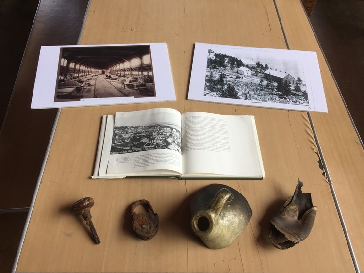
Archaeology
Our Archaeology program investigates the history of granite production and indigenous presence on Hurricane Island and within Penobscot Bay. Fieldwork ranges from demonstrations of granite quarrying and dressing techniques to lessons on indigenous stone working. Each year, investigators and students survey and map remaining anthropogenic features and conduct excavation work on selected locations. This work enhances our understanding of the Wabanaki presence and offers a more nuanced understanding of the lives and habits of the significant granite working population who lived on the island in the late 1800's. This is a highly specialized program due to the unique and rich history of the island, of which signs can still be seen today. Learn more about our archaeology field program.